
No rainforest in the Siskiyous. No rainforest in the Gorge either, Gunky.

Into Oregon's largest old-growth rainforest
Drift Creek Wilderness features solitude and dense coastal forest
www.statesmanjournal.com
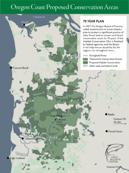
Tillamook Rainforest - Wild Salmon Center
The North Coast forests hold six extraordinary wild salmon rivers, and they deserve balanced management to protect all of their natural and economic benefits.
 I pass through Oregon regularly, idiot. It's next to Washington.