The writing is irrelevant.
I cannot read Arabic so yeah it's irrelevant.
Try again. You'll eventually get it. I did immediately after you told us that the Google satellite could get the same clarity and resolution of that location.

The writing is irrelevant.
Wrong. Try again. Look again. See the difference between Google and KH-11 satellites.

I guess you guys are all rocket scientists. You know the rest.
Wrong. Try again. Look again. See the difference between Google and KH-11 satellites.
Not sure on their differences. B&W is often used for higher resolution, but I'm certain the KH-11 can take color pics since, allegedly, it's based upon the Hubble.
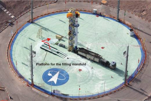
^^^There's nothing in that picture of particular interest. You have a launch pad with a service gantry on it. That's fixed and common for missile launch sites. There's a command bunker off to the left with a communications trench (covered) going from it to the pad. There are several service vehicles and a TEL vehicle present. The writing is irrelevant.
Crateology was the 'science' of identifying the contents of Soviet shipments to the Island of Cuba carried out by the Central Intelligence Agency during the Cuban Missile Crisis.[1]
Crateology has declined as a discipline in recent years due to globalisation and the decline in the usage of custom made wooden crates in favour of standard metal shipping containers. Though making the world intra-connected and smaller, globalisation has resulted in the loss of not merely a science, but a 'beautiful art form'.[2]
Off topic
It doesn't take even a janitor scientist to see what I see after T.A. pointed out that the Google satellite could have taken the same picture with the same clarity.
Did WWIII start over this and I missed it?


There are plenty of better images on the Internet too. Many are taken from ground level.
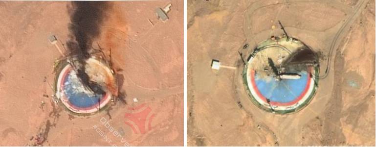
Civilian satellite images of the accident
I am waiting for you to notice something. I gave a hint to Gay Uncle.
I know you can see it.
Here's a hint: The Google Maps images are always taken directly down.

That's a matter of presentation. Note this picture is at an angle:
You might as well just cough up what you are hinting at.
I know you can see it.
Here's a hint: The Google Maps images are always taken directly down.
No, they aren't. Go to any large city and take a look at the skyscrapers etc. They are usually taken at a slant.
So no right answer (even though they were close) from T.A. and Uncle as of yet?
If you both give up, you will get my answer. (Both of you got 90% correct).
Just spit it out already...