
Members banned from this thread: AProudLefty |
 Oderint dum metuant
Was 2020 a Record-Breaking Hurricane Season? Yes, But. .
- The increase of named storms is very likely due to technological improvements, not "climate change"
- Since 1995 more short-lived storms have been designated named storms than previously in history
The National Hurricane Center use the designation named storms to refer to tropical storms, subtropical storms, hurricanes, and major hurricanes.) They even reached into the Greek alphabet for names for just the second time ever. The United States was affected by a record 13 named storms.
However, the number of named storms is only one measure of the overall measure of a seasons activity. And indeed, for the 2020 season, other measures of Atlantic tropical storm and hurricane activity were not record breaking. For example, the number of hurricanes (14) was well above average, but fell short of the previous record of 15 hurricanes.
For overall monitoring of tropical storm and hurricane activity, tropical meteorologists prefer a metric that combines how strong the peak winds reached in a tropical cyclone, and how long they lasted called Accumulated Cyclone Energy or ACE. By this measure, 2020 was extremely busy, but not even close to record breaking.
In fact, with a total ACE of 180 units, 2020 was only the 13th busiest season on record since 1878 with seasons like 1893, 1933, 1950, and 2005 substantially more active than 2020. While there is a long-term increase in recorded ACE since the late 1800s, its quite a bit less dramatic than the increase seen with named storms.
There also is a pronounced busier/quieter multi-decadal (40- to 60-year) cycle with active conditions in the 1870s to 1890s, late 1920s to 1960s, and again from the mid-1990s onward. Conversely, quiet conditions occurred in the 1900s to early 1920s and 1970s to early 1990s.
So why would the record for named storms be broken in 2020, while the overall activity as measured by ACE is not even be close to setting a record?
The answer is very likely technology change, rather than "climate change".
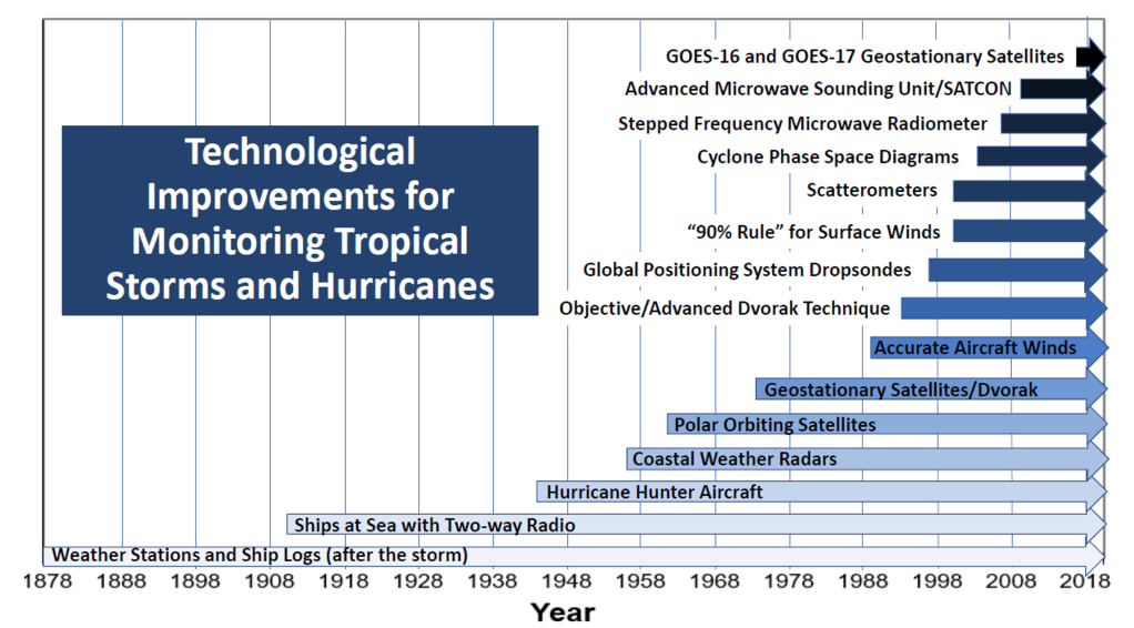
Today we have many advanced tools to help monitor tropical and subtropical cyclones across the entire Atlantic basin such as geostationary and low-earth orbiting satellite imagery, the Hurricane Hunter aircraft of the U.S. Air Force Reserve and National Oceanic and Atmospheric Administration (NOAA), coastal weather radars, and scatterometers (radars in space that provide surface wind measurements).
In addition, the instrumentation and measuring techniques used by the satellites, aircraft and radars are continually improving.
These technological advances allow us at the National Hurricane Center to better identify, track, and forecast tropical and subtropical cyclones with an accuracy and precision never before available.
This is great news for coastal residents and mariners, since these tools help us provide the best possible forecasts and warnings to aid in the best preparedness for these life-threatening systems.
Such technology, though, was not available back at the advent of the U.S. Signal Services tropical monitoring in the 1870s.
Without these sophisticated tools, meteorologists in earlier times not only had difficulty in forecasting tropical cyclones, but they also struggled in even knowing if a system existed over the open ocean.
In the late 19th and early 20th Centuries, the only resource hurricane forecasters could use to monitor tropical cyclones were weather station observations provided via telegraph. Such an approach is problematic for observing much less forecasting tropical cyclones that develop and spend most of their life cycle over the open ocean.
Heres a timeline of critical technologies that have dramatically improved tropical meteorologists ability to see and monitor tropical cyclones:
The upshot of all of these advances in the last century is much better identification of the existence of tropical cyclones and their strongest winds (or what meteorologists call Intensity).
So, the further one goes back in time, the more tropical cyclones (and portions of their life cycle) were missed, even for systems that may have been a major hurricane.
This holds for both counting named storms back in time as well as integrated measures like ACE.
Our database is incomplete and has as statisticians would say a severe under-sampling bias that is much more prominent earlier in the record. HURDAT2 our Atlantic hurricane database is an extremely helpful record which is a by-product of NHCs forecasting operations, but it is very deficient for determining real long-term trends.
(Its important to point out that many data entries in HURDAT2 for intensity and even the position of the named storms are educated guesses as opposed to being based on observations before the 1970s advent of regular satellite imagery).
To be able to examine questions about any impact from "man-made global warming" (aka "climate change") on long-term changes in the number of named storms, for example, one must first account for the massive technology change over the last century.
From a warning perspective for mariners and coastal residents, it is very beneficial that the National Hurricane Center is now naming (and recording) these Shorties. But without accounting for how technology affects our records, one can come to some unfounded conclusions about true long-term changes in named storm activity.
In addition, it is worth pointing out, but perhaps not too surprising, that it has been shown by the researchers at Princeton University and at GFDL (Villarini et al. 2011, Journal of Geophysical Research) that the observed increase in Shorties has no association with any environmental factor known to influence named storms including "man-made global warming". It is therefore reasonable to conclude that the dramatic increase in the number of these Shorties is simply due to better observational technology.
https://noaanhc.wordpress.com/2021/06/30/was-2020-a-record-breaking-hurricane-season-yes-but/
 Posting Rules


 Reply With Quote
Bookmarks